IntersectionFeatureCollection
Description
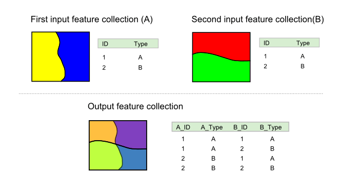
The vec:IntersectionFeatureCollection process intersects two feature collections using spatial intersection and attribute combination.
The geometries in the feature collections can be intersected (intersectionMode) by a spatial intersection (INTERSECTION) or the output can use the original geometries from either inputs (FIRST or SECOND) without any spatial processing.
The attributes of the output feature collection are determined by a list of attributes from both of the input geometries, specified as two lists, one from each input. If these parameters are left blank, all attributes will be used.
In addition to the above parameters, the areas of each feature collection can be included as attributes, as well as the percentage of intersection.
The names of the output attributes will be altered. The new attribute names will consist of the originating feature collection, an underscore, and the name of the original attribute (feature_attr).

vec:IntersectionFeatureCollection
Inputs and outputs
vec:IntersectionFeatureCollection accepts Feature collection inputs and returns Feature collection outputs.
Inputs
| Name | Description | Type | Usage |
|---|---|---|---|
first feature collection |
First feature collection | SimpleFeatureCollection | Required |
second feature collection |
Second feature collection | SimpleFeatureCollection | Required |
first attributes to retain |
Attribute from first feature collection | String | Optional (any number) |
second attributes to retain |
Attribute from second feature collection | String | Optional (any number) |
intersectionMode |
Specifies geometry computed for intersecting features. Options INTERSECTION (default)—Computes the spatial intersection of the inputs, FIRST—Copies geometries directly from the first input feature collection, SECOND—Copies geometries directly from the second feature collection |
IntersectionMode | Optional |
percentagesEnabled |
If True, will output feature area percentages via the attributes percentageA and percentageB |
Boolean | Optional |
areasEnabled |
If True, will output feature areas via the attributes areaA and areaB |
Boolean | Optional |
Outputs
| Name | Description | Type |
|---|---|---|
result |
Output feature collection | SimpleFeatureCollection |
Usage notes
- The first input feature collection must not consist of point geometries.
- Both input feature collections are assumed to be in the same CRS. The output feature collection will have the same CRS as the input.
- We recommend using the smallest feature collection in the
second feature collectioninput, as this will reduce the time required to run the process. - An
INTERSECTION_IDfield is automatically added that will contain a unique integer value for each output feature. - If either of the parameters
areasEnabledorpercentageEnabledare set to True, both of the feature collections must contain polygon features. - Areas of resulting intersection polygons, stored in the
areaAandareaBattributes, are expressed in the areal units corresponding to the input feature collections. For example, if coordinates are expressed in meters, areas will be expressed in square meters. - Attributes values are copied from the input layers but are not modified, so be aware that attributes depending on the specific properties of the inputs geometries are likely to be invalid for the resulting layer.
- If the input layers contain an attribute recording an area measurement, and you would like to have a similar area measurement for the output feature collection, the area measurement can be recalculated by setting the
areasEnabledparameter to True. - For appropriate attributes, a new value can be calculated from the original values and the percentage value added when the
percentageEnabledflag is set to True. However, this assumes a regular distribution over the feature area. For instance, in the case of an attribute representing a population count for a polygon geometry, this calculation will assume that the population is regularly distributed and the population density is constant.
Examples
Streets that cross parks
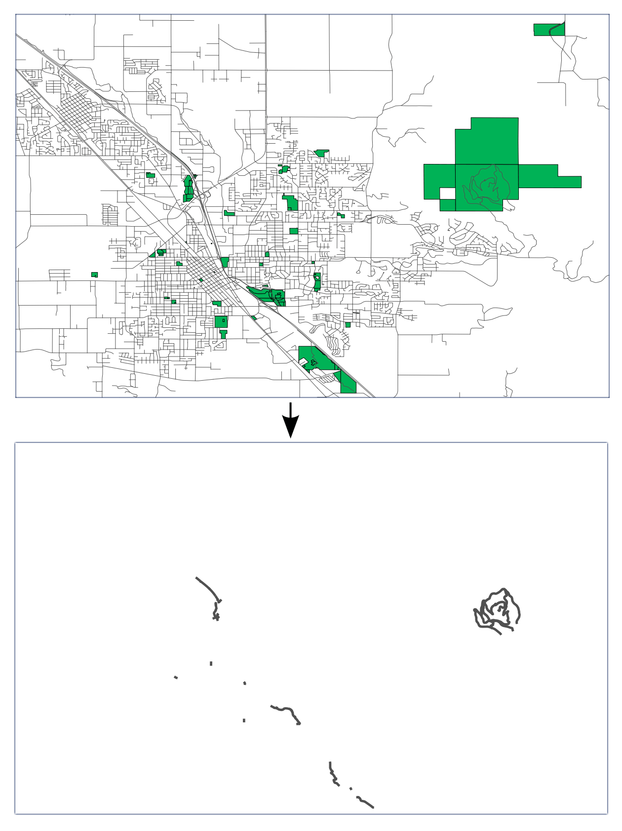
Intersecting medford:streets and medford:parks to produce a feature collection of those street sections that cross a park.
Input parameters:
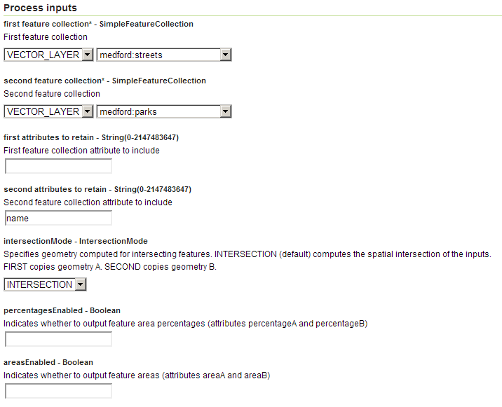
first feature collection:medford:streetssecond feature collection:medford:parksfirst attributes to retain: [blank]second attributes to retain:nameintersectionMode:INTERSECTIONareasEnabled: FalsepercentagesEnabled: False

vec:IntersectionFeatureCollection example #1 parameters
The resulting schema contains all the attributes from the medford:streets feature collection, plus an attribute from the medford:parks collection, containing the name of the park crossed by the street section represented by that feature.

vec:IntersectionFeatureCollection example #1 output
Note
This example illustrates the problem mentioned above where attributes representing some properties of the default geometry are not updated when the geometry is modified. In particular, the length attribute from the medford:streets feature collection is preserved with its original values, even though this value is no longer correct in the resulting feature collection.
Identifying inland volcanoes
Intersecting world:volcanoes and world:borders to produce a feature collection of inland volcanoes only, adding the name of the country the volcanoes belong to.
Input parameters:
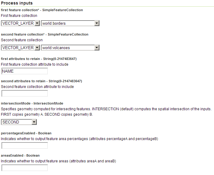
first feature collection:world:borderssecond feature collection:world:volcanoesfirst attributes to retain:NAMEsecond attributes to retain: [blank]intersectionMode:SECONDareasEnabled: FalsepercentagesEnabled: False
The resulting schema contains all the attributes from the world:volcanoes feature collection plus an attribute from world:borders containing the name of the country the corresponding volcano belongs to.

vec:IntersectionFeatureCollection example #2 parameters